
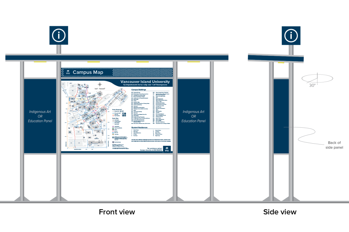
*Please note, this image is a conceptual rendering only.
Background
Clear wayfinding signage is essential to help campus users navigate VIU's steep Nanaimo campus. The existing exterior wayfinding signage is an ad-hoc mixture of signs that have been installed over the course of many decades. This assortment includes old wood freestanding signs as well as signs mounted on metal poles, railings, concrete walls and buildings among other things. The information provided includes campus maps, directional arrows, building names and destinations. It is presented in various formats, fonts, colours and graphics. Because of this, the signage is not universally accessible.
VIU’s interior wayfinding signage is a mixture of two systems, both in which standards are outdated and not universally accessible.
Project overview
This project aims to standardize wayfinding signage at VIU to provide a clear and consistent system for pedestrians to find their way around campus. The system will respond to Universal Access requirements including Rick Hansen Foundation (RHF) Guidelines and Canadian Standards Association (CSA) standards, will be inclusive and inform users of a multitude of diverse abilities, and will be consistent with institutional branding.
The standardized program consists of two parts: an exterior wayfinding signage system for Nanaimo campus and an interior wayfinding signage system for all VIU campuses.
In addition to the installation and replacement of physical signage, new guidelines will be developed.
Benefits
- An improved, inclusive campus wayfinding experience for all campus users of diverse abilities.
- A comprehensive wayfinding signage system that assists navigation from campus gateways to destinations.
- Standardized wayfinding signs that align with institutional branding.
- New VIU wayfinding signage guidelines that can be followed for future constructions.
Public consultation
Campus Development ran a public survey and conducted interviews with 29 departments and programs across campus from May to September 2021, asking students and employees to share their experiences and suggestions about wayfinding signage on the Nanaimo campus. The thoughtful input helped us develop a comprehensive, accessible and inclusive wayfinding signage system.
Key results:
- We received 470 responses from the VIU community, which provided extensive data on how people use the campus.
- Our top priority will be improving building number and name signs so they are larger, more obvious, consistent and in higher contrast.
- We identified key locations for signs and maps, including parking lots, the library, cafeteria, Residences, transit exchange, etc.
- Respondents noted hard-to-find buildings include the library and Campus Store, Building 356, Building 345, the gym, Building 200, VIU High School, etc.
- Respondents shared that the buildings above Tamagawa Gardens are difficult to find by following the pattern of building numbers because they were labelled 300-series like the level below. A Building Renumbering project was developed to create a "400's level" on campus.
- Marking building entrances with floor numbers is preferred.
- Ensure new signs and maps are accessible for everyone and well-lit when it is dark.
- Beautification of the signs and maps is desired while keeping the content concise.
- Digital options for certain signs and maps are expected.
More details of public consultation results and key findings are also available.
*Please note, this image is a conceptual rendering only.
Signage design and implementation phases
Currently, we are installing new exterior wayfinding signage in three phases:
| Phase | Timeline | Signage Type |
| 1 | Fall 2022 to summer 2023 | Building tags |
| 2 | Fall 2023 to summer 2024 | Pedestrian wayfinding signs |
| Regulatory signs | ||
| 3 |
Not earlier than fall 2024 |
Vehicular wayfinding signs |
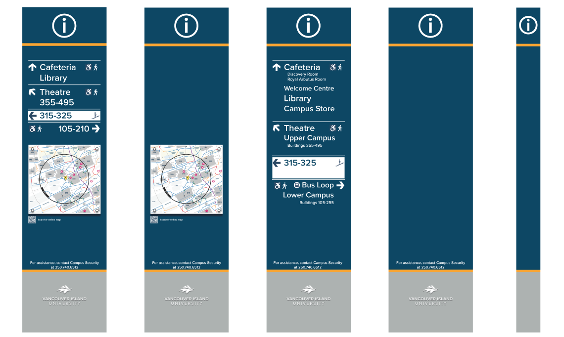
Removal of building names
We learned from the public consultation that many building names are confusing, incorrect, obsolete or do not indicate all the programs and services in the building. This is because the arrangement of space and how it is shared among programs and services change in VIU’s buildings over time.
We also learned that students primarily refer to buildings by building number, as that is how they see on their timetables.
Moving forward, only building numbers will be included on signs. Building names will be listed on all campus maps, including both printed copies and digital versions. This allows for easy updates to reflect dynamic changes over time.
Exceptions to this strategy include buildings such as the library, gym, and Malaspina Theatre. These destinations also attract a significant number of off-campus visitors, who may not be familiar with or use the building numbers. Additionally, some buildings are named in honour of a person or business that was a major contributor to its success. Both physical building number and building name signs are included on these buildings.
Buildings with names on them include:
- 108 Windsor Plywood Trades Discovery Centre
- 164 Hairdressing
- 170 Shq'apthut - A Gathering Place, Services for Aboriginal Students
- 185 Lower Cafeteria, Bakery
- 190 Gymnasium
- 210 Dr. Ralph Nilson Centre for Health and Science
- 255 The Richard W. Johnston Centre for International Education
- 305 Library
- 310 (2nd floor) Malaspina Theatre
*Please note, this image is a conceptual rendering only.
Q&A
Q: What is the campus wayfinding strategy in the new system?
A: Campus wayfinding begins when you approach the campus, where entrance signs will help you find the best entrance – and if you drive, the best parking lot.
Campus maps are strategically located near campus entrances, parking lots, the transit exchange and along the main staircase for you to find a general direction to your destination.
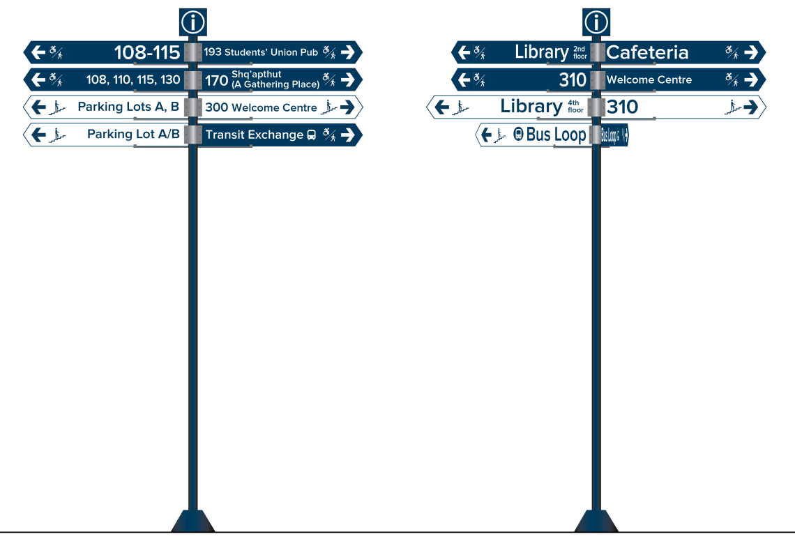
As you walk toward your destination, you will see directional signs and area maps at major intersections (also known as decision points) to confirm your route and give your further directions. Accessibility signs will be located along the way to indicate accessible routes.
As you approach the destination, you will be able to locate the right building by building numbers and names. If the building entrance/accessible entrance is hidden, a building entrance indicator will help you locate it.
The floor number and a building directory will be available at the building entrance. Then the interior wayfinding signage system will guide you to the room, service or facility that you are looking for.
Q: How is universal access included in the design of new signage?
A: All signage will comply with Universal Access requirements including RHF Guidelines and CSA standards, use large types, pictograms and Arabic numbers where possible, and have high contrast and clean design.
Different colour patterns will be used on exterior directional signs, where white content on blue background indicates stair-free routes, while blue content on white background represents routes with stairs.
The existing accessibility wayfinding signs on campus, including ramp signs, elevator signs and washroom signs, will be integrated into the system. The new campus map with comprehensive accessibility information will be used where a campus map is needed.
We are also exploring digital wayfinding solutions that can help persons with impaired vision navigate the campus.
Q: When will a digital navigation option be available for campus users?
A: We hear the desire for a Google Maps-style, turn-by-turn campus navigation app. We are actively looking for available solutions in the market and are in contact with a few potential providers. We do not have a timeline yet, as we want to investigate each product closely to ensure the product that we select meets the VIU community's needs and provides an excellent digital navigation experience for campus users of diverse abilities.